Hunt Corp intentionally damaged and destroyed many Ewa Field historic and cultural sites without required review and consultation.
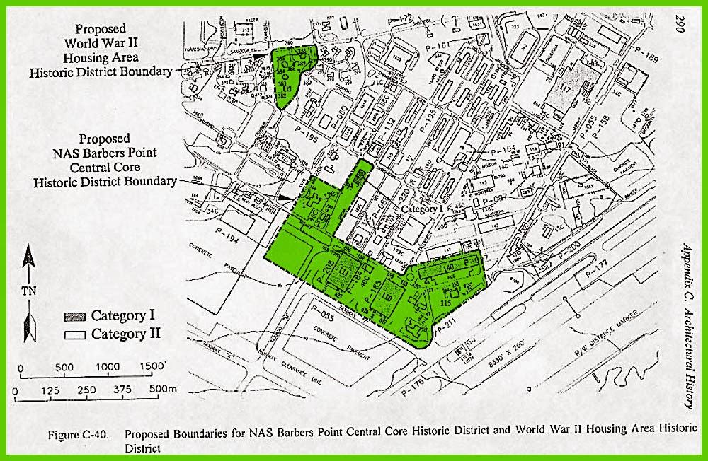
1943 Squadron Wall, a national register eligible Ewa landmark- in use by Navy and USCG squadrons up until 1999. Illegally knocked down by Hunt Corp just after it was officially identified in the 2011 Hunt AECOM Ewa Battlefield – Mason Architects study. Navy NavFac real estate admitted it was a “mistake” and would be rebuilt. But nothing has ever happened since it was knocked down. All documented NHPA violations. Destruction done by a Hunt Corp subcontractor and every wall piece removed to hide any evidence.
Hunt contractor deliberately ran a tracked BobCat front loader back and forth over the historic documented Dec 7 battle pool site to damage its historic integrity. Hunt had their widely acknowledged useless “security” to not report intentional damage sub-contractors did. Navy NavFac did nothing when sent all the photo evidence.
1944 Quonset Hut 1545 had large holes cut into it, interior and floor repainted destroying unique WW-II historic markings and interior features –without any NHPA consultation. 1545 building was in fact not even on Hunt Corp leased property! Officially identified in the 2011 Hunt AECOM Ewa Battlefield – Mason Architects study, Hunt also allowed subcontractors to rip out MCAS Ewa Field metal, copper wires, cut down historic 1941 power poles, and use heavy tracked equipment on the 1941 battlefield ramp during 2012 KREP solar farm construction. Illegally dumped construction materials and contaminated materials on City property until caught and fined by a City building inspector.
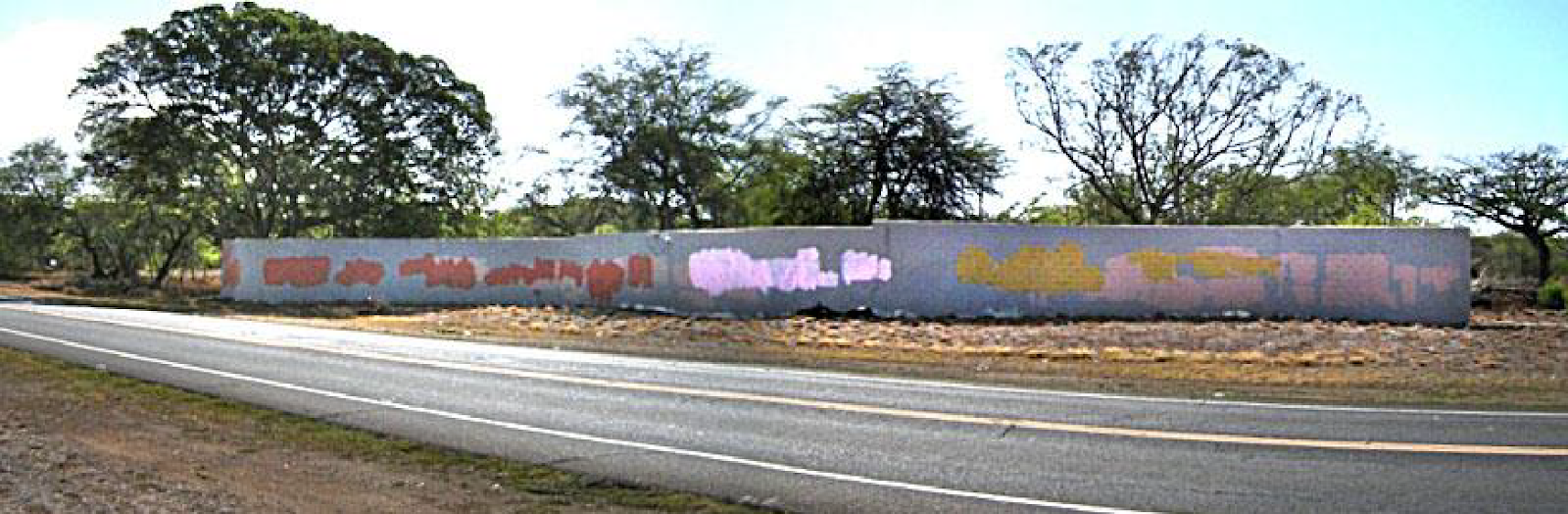
Ewa Hawaiian coral wall knocked down, a national register eligible historic Ewa landmark SIHP # 50-80-12-8939 – knocked down by Hunt Corp. SHPD, Navy real estate said it was a Federal ARPA violation – a federal crime. But nothing ever happened to restore or protect it. Hunt contractors knew they were destroying a SHPD SIHP historic cultural site and that Navy NavFac wouldn’t do anything.
1943 Building 1141 illegally knocked down by Hunt Corp. Officially identified in the 2011 Hunt AECOM Ewa Battlefield – Mason Architects study. No NHPA review of consultation. Interior photos show it was in good condition and no justification to destroy it. Building 1141 was historically associated with 1943 US Navy WW-II SeaBees high quality construction, documented in photos and NCB histories. Hunt Corp “ready to deal- sell” signs up all over it immediately after being knocked down.
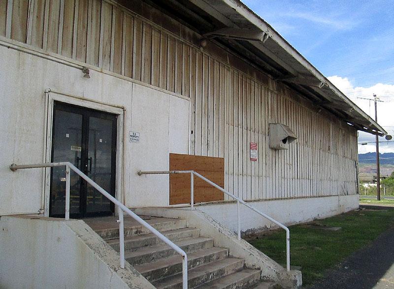
Historic National Register building 972 repeatedly damaged. Listed as an important National Register Cold War headquarters facility, POW-MIA office, Hunt Corp SITE OFFICE was only 50 yards away yet allowed YEARS of homeless, drug parties, gang damage, looting the building year after year. It was in extremely good condition prior to Hunt’s area takeover. This is all extensively documented in photos and videos. Navy NavFac did absolutely nothing about it until a national level veterans group complained to the Navy and then a few efforts were made to clean up debris and easy access.
Illegal Pilings Deal – secret Hunt Corp AmVets deal- huge long pilings from Hunt contractor friends Watts received a nearly $1 million tax write off and avoided paying big construction materials disposal fees by money laundered through a newly created AmVets Hawaii 501-c-3 front. Hunt approved permission to open the usually locked Hunt “security” gate to allow a six hour long construction material dump on City property using heavy trailer trucks, huge front loaders, all extensively damaging historic bullet marked Ewa battlefield concrete pads where Marines died. The cracked pads, deep tire marks still visible many years later and documented, including by drone photos. Intentional violations of City ordinances, State laws, federal laws.
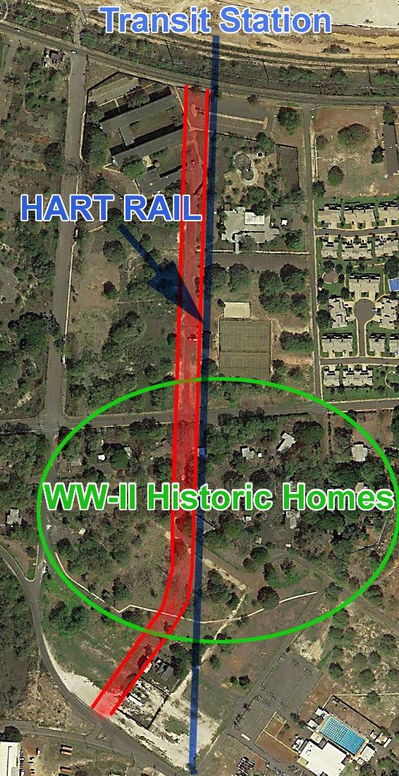
Hunt Corp directly involved in knocking down – 1942-1999 NASBP memorial in deal with AmVets Hawaii. Hunt Corp wanted the historic memorial removed to market the parcel as TOD Transit Oriented Development HART rail station. Navy maps identified the memorial site as facility site 1920. While Navy NavFac later claimed it was just a “marker,” HCDA, NASBP history records, base closure ceremony all state it was a memorial to all service members and those killed in combat (1942-1999,) which is why it was located directly in front of the NASBP base command headquarters. A massive dishonor to the community and veterans. A really evil greedy insider deal arranged and endorsed by Navy NavFac. A well documented history of a massive fraud.
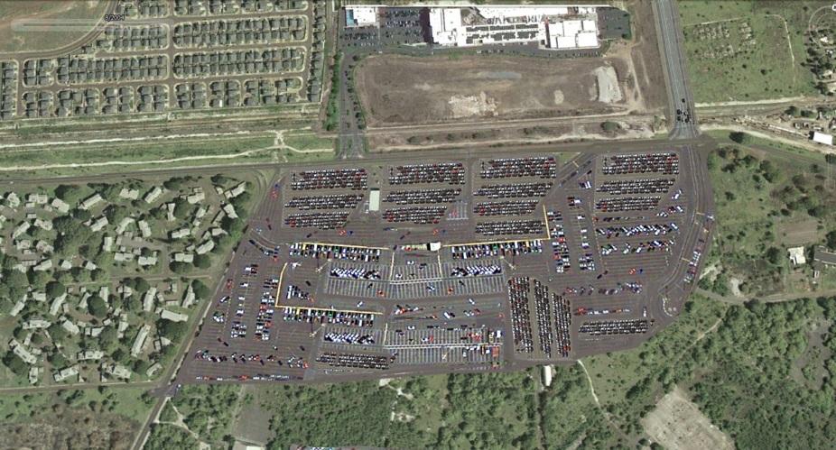
Hunt has continuously allowed car racers and motorcycles to damage the 1941 Ewa Field concrete ramp every week, as everyone can hear the screeching, squealing tires every Saturday and Sunday. Metal shreds, burned rubber everywhere, even previous barriers have been cleared away to give all illegal destructive events full access to damage the 1941 battlefield area as much as possible. Hunt brought in a TV production company to clear the ramp making it ideal for drag racing, burning rubber and drifting. Hunt paid to “rent out” 1941 Ewa Battlefield ramp where US Marines died in combat.
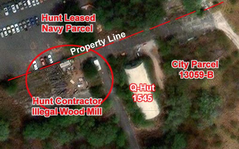
Hunt Corp allowed illegal wood harvesting, wood milling on City parcel 13059-B
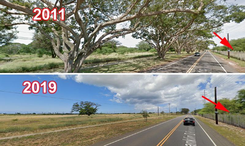
Before tearing down the historic 1942 fence, Hunt Corp of Texas and HCDA had all the large historic shade trees along Roosevelt Avenue chopped down – and they wound up at Hunt contractor illegal wood milling Operation on City parcel 13059-B !
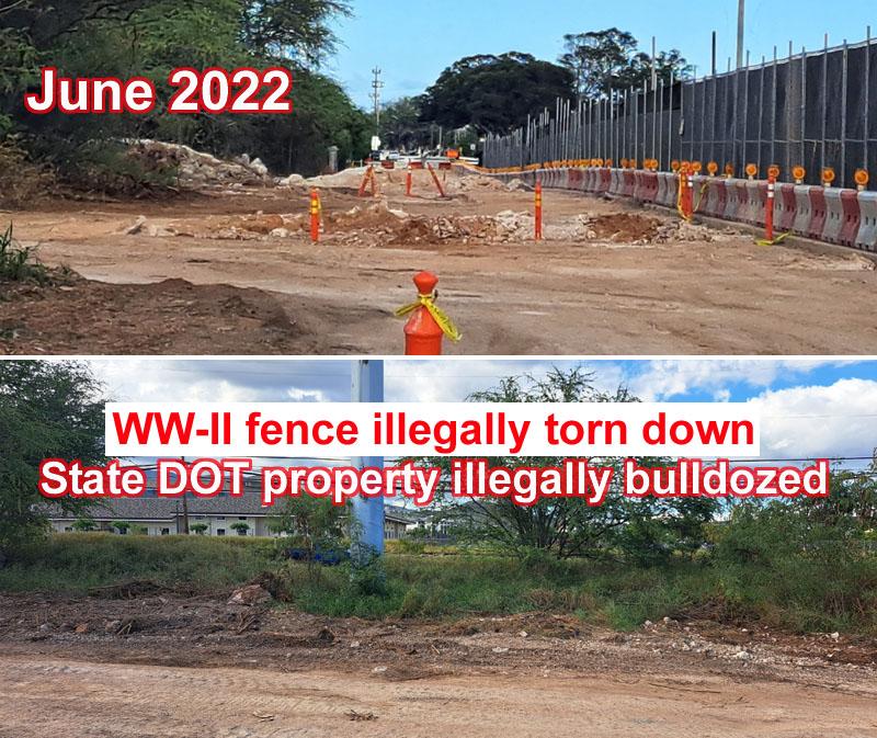
Hunt Corp of Texas tore down the historic 1942 fence and then bulldozed State DOT property to expand their new development road, all without any SHPD-State DOT consultation!
Hunt Corp later tried to get the City to remove the historic Franklin D. Roosevelt name to further cover up their historic criminal activities against the Ewa community. HCDA approved all of this.
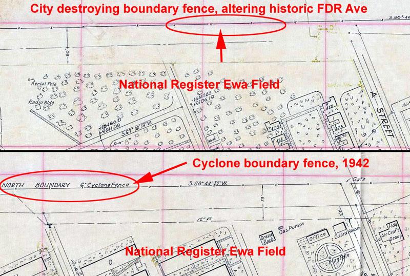
1942 CPNAB (Contractors Pacific Naval Air Bases) drawings show the North Boundary Cyclone Fence being put up on the north side of MCAS Ewa Field along what would later be called Franklin D. Roosevelt Avenue. In 1942 none of the streets had names, however later they were named for Marine fighter pilots killed in combat and/or awarded the Medal of Honor.
• 1943 Squadron Wall
1943 Squadron wall – identified in the 2011 AECOM Hunt-Navy Ewa Battlefield report as a significant historic structure and then almost immediately knocked down and meticulously removed virtually overnight without any public notice. The Navy later stated that this was a “mistake” but never did anything further. Message to Hunt: Neither Navy nor HCDA will say or do anything, laws and statutes mean NOTHING in HCDA Kalaeloa. Just the start of many other illegal site demolitions as Navy NavFac approves of federal violations. The Red Hill fiasco has further clearly proved Navy NavFac has a longtime pattern of arrogance, lies and deception.
• Ewa Hawaiian coral stone wall
February 2018: Federal ARPA Violation: The Archaeological Resources Protection Act of 1979 (ARPA) Well over century old historic Ewa coral wall destroyed by Hunt Corp without public notice. Only widespread public outrage caused the Navy and SHPD to make an investigation. This repeatedly shows that State and Federal laws, statutes, mean nothing on the “Hunt Texas Ranch.” This was done by intent, knowing this was a culturally important Ewa SIHP site.

• 1943 Building 1141
Building 1141 illegally knocked down by Hunt Corp identified in the 2011 AECOM Hunt-Navy Ewa Battlefield report, without any public consultation. This is a federal NHPA violation however as usual the always corrupt Navy NavFac Real Estate office never does anything to stop Hunt Corp of Texas from doing these and many more illegal acts in HCDA Kalaeloa.
• 1944 Quonset Hut 1545
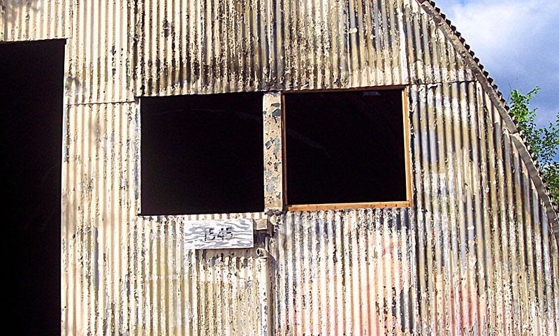
Hunt was paid by a TV show to allow them to cut holes in the historic WW-II Quonset hut, paint over WW-II bay markings where wounded Marines on stretchers flown from Pacific island battles were sheltered before being taken to the Navy hospital (today Camp Smith.)
Cut up, doors, windows torn off, and it’s NOT even on their leased property!
Hunt Corp of Texas biggest new scheme on a massively damaging scale
Hunt Corp of Texas hopes to destroy all of ancient Kanehili - MCAS Ewa with a massive, environmentally insane 4000 car parking lot with a major highway crossing through the Hawaiian Railway train yard and museum, putting Hawaiian Railway out of business.
Hunt-Navy NavFac refuse to do an EIS even though this insane scheme would create hugely damaging environmental consequences accumulating very high localized temperatures, massive flood runoff, severe damage to the subsurface karst ecosystem killing off limu, sealife, fisheries with detergents, gas, oil and other toxic chemicals.
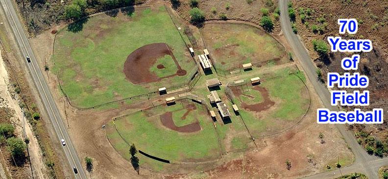
Hunt Corp of Texas forced closure of hugely popular
70 year old ball park- today overgrown with weeds, unused by once national champion Ewa youth baseball teams
Hunt has already forced the closure of the hugely historic and popular Pride Baseball Field where decades of Ewa Little League Teams and Ewa national champions played and baseball legend Joe DiMaggio played in 1945 while flying Marine Corsair fighters.
Ewa’s Pride Field – Historic Open Recreational Space and Baseball Field
http://barbers-point.blogspot.com/2015/06/ewa-pride-field.html
Ewa’s Popular Batter’s Box Closing
https://leewardreporter.com/ewas-popular-batters-box-closing/
BATTERSBOX BATTING CAGES WILL BE CLOSING.
LAST DAY OF OPERATIONS WILL BE OCT. 19, 2014
Todd Koishigawa and his father maintain the very popular Ewa Pride Baseball Field by themselves at their own expense, because the City stopped maintaining it several years ago. So then Hunt Corp killed it!
Ewa West Oahu has produced top championship baseball teams over the years and most have their practice and game history through Pride Baseball Fields. Koishigawa and his father have brought top baseball training events to the field allowing local West Oahu kids exposure to professional baseball player expertise and advice. A massive community resource loss!
Historic homes hacked up, set fire, destroyed by Hunt for their land development
Former NAS Barbers Point Historic Homes Hacked Up and Fires Set For "Fire Seminar"
http://barbers-point.blogspot.com/2013/10/Navy-Homes-Trees-Burned.html
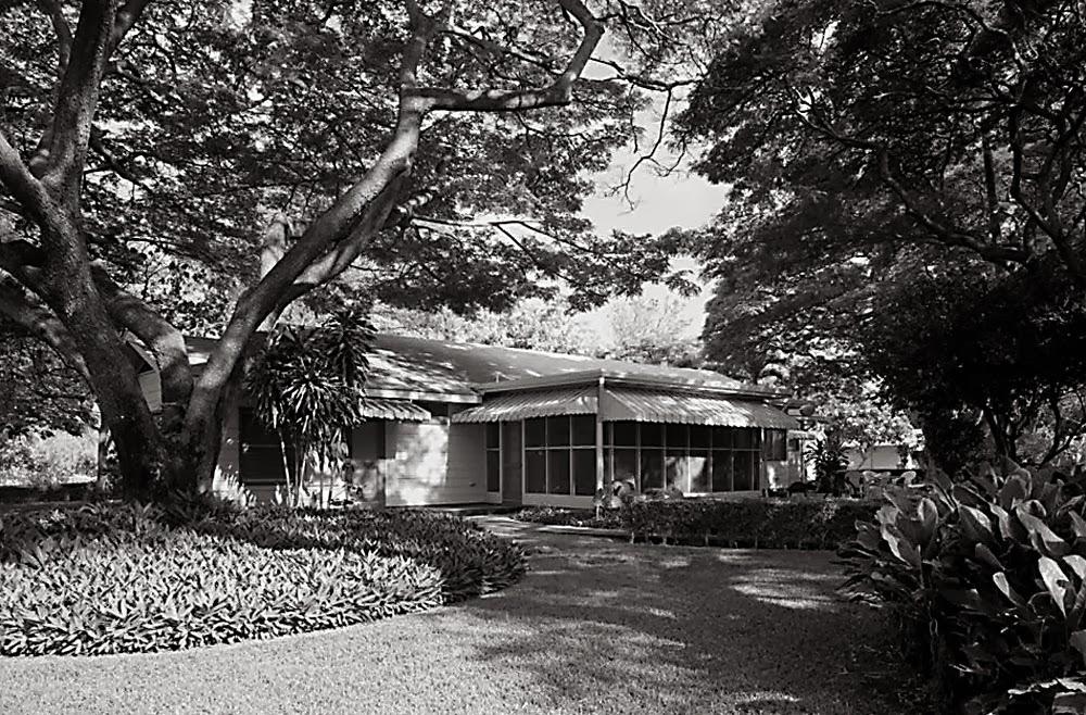
Almost no one, especially not the State of Hawaii Preservation Department (SHPD) or Hawaii Community Development Authority (HCDA) will explain why beautiful homes, listed on State and Federal lists, are being allowed to be hacked up by an out of state contractor in the "place of excellence" called Kalaeloa... formerly known as Naval Air Station Barbers Point.
Houses painted with flames coming from windows, fires set all over the area in a firebug free-for-all... More and more holes hacked into the historic national register eligible home rooftops- but yet apparently "no one in authority" seems to notice anything unusual happening in the "place of excellence" Kalaeloa...
The once beautiful, lush and shady tree canopied area of the former Naval Air Station where WW-II era homes were supposed to be preserved and placed on the National Historic register is now being turned into a zombie like "Homes of Horrors' setting.
Kalaeloa Fires, Vandalism Plague Former Barbers Point Navy Base,
But Some Don't Notice
http://barbers-point.blogspot.com/2013/10/Kalaeloa-Arson-For-Profit.html
Three brush fires in Kalaeloa latest in string of suspicious blazes
Fire investigators are looking into three brush fires that they believe may have been intentionally set Monday morning within 90 minutes in Kalaeloa. Capt. Terry Seelig, Honolulu Fire Department spokesman, said today's incidents are the latest in a string of 20 suspicious fires at Kalaeloa since the beginning of the month.
By William Cole Oct 15, 2013 Honolulu Star-Advertiser
http://www.staradvertiser.com/s?action=login&f=y&id=227775671
There have been 20 brush and rubbish fires this month. Dozens of power poles have been felled by metal scavengers. Residents report manhole covers being taken. One observer says the word is out that security is lax and the area is "wide open."
Coincidently, all of these highly concentrated fires being set are all within the same area around and within the historic WW-II homes community, and also coincidently, where HCDA plans a major highway and rail transit line project. Having large canopy trees and historic homes decimated and destroyed creates the "eyesore" effect so necessary to then bring in the bulldozers...
Authorities investigate Kalaeloa vandalism HAWAII NEWS NOW Oct 16, 2013
http://www.hawaiinewsnow.com/story/23706644/authorities-investigate-suspicious-kalaeloa-vandalism
Honolulu authorities are trying to determine if an arsonist is behind several fires in Kalaeloa.
Earlier this week, firefighters responded to three fires within an hour of each other in the same area. Officials with the Honolulu Fire Department say there have been 20 brush fires in Kalaeloa since the start of October.
Fire department crews say they also put out multiple fires in August and September.
Investigators say there appears to be a pattern, and HFD is now working with the Honolulu Police Department to investigate the fires.
Kalaeloa fires trigger arson concerns - Jim Mendoza Hawaii News Sep 17, 2013
http://www.hawaiinewsnow.com/story/23459021/kalaeloa-fires-trigger-arson-concerns
Coincidently, all of these highly concentrated fires being set are all within the same area around and within the historic WW-II homes community, and also coincidently, where HCDA plans a major highway and rail transit line project. Having large canopy trees and historic homes decimated and destroyed creates the "eyesore" effect so necessary to then bring in the bulldozers...
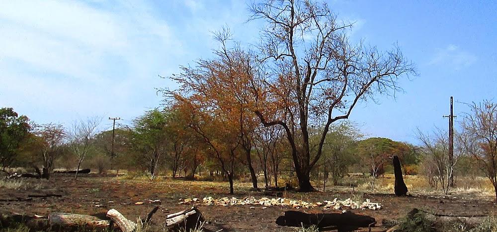
Barbers Point - Kalaeloa: Big Historic Trees Dying Off, Hacked Up, Arson Burned
http://barbers-point.blogspot.com/2013/09/Big-Ewa-Trees-Dying.html
Former Naval Air Station Barbers Point once had some of the largest groves of large historic Banyans and Monkey Pod Trees in all of West Oahu when the base was still in operation.
One might think that large canopy trees would be a great land and property asset, especially out in hot and sunny Ewa where they provide great shade and lower ground temperatures. But to some land developers who only think in terms of square foot values or maintenance issues, large trees are a big problem that they really want to have go away.
The nostalgic days of large yards around homes that made up this former Navy housing area are over. Packing in lots of buildings and a few small palm trees would be much more profitable.
How to do it without bulldozing down large canopy trees that doesn't make for good TV news?
Perhaps a slow "Agent Orange Disease" way? Or "allow" wood cutters in to hack up trees and prune them back to near death?
Or what if someone came in and did a really good job of setting off high intensity "grass fires" and the trees all "eventually died" from the inferno?
Actually this is all a paid off racket like hiring professional arsonists. Below is an example of the “Fire Seminar” group burning down two large Navy homes in a National Register eligible historic district. Note that the time is 3:28 p.m. in the afternoon! How convenient! I know for a fact these homes were set up to be burned down. Note also that the news story says that these homes were NOT former Navy homes, but instead “plantation homes.” Another outright lie planted by the big land developer in HCDA Kalaeloa where it is all a Wild West crookville.
Fire destroys 2 abandoned buildings in Kalaeloa
Two abandoned houses were destroyed and a brush fire burned a quarter of an acre on Boxer Road near Saratoga Avenue in Kalaeloa on Monday afternoon, fire spokesman fire Capt. David Jenkins said.
No one was injured and no structures of any value were threatened, Jenkins said.
About 30 firefighters responded to the 3:28 p.m. fires.
When firefighters arrived at 3:34 p.m., they found one structure fully involved in flames, and a second house partially on fire.
Jenkins said there may have been multiple ignition sources, and that the house fires did not necessarily spark the brush fire, which was separated from the homes.
There was heavy overgrowth of brush and trees, he said.
Jenkins said these are very old plantation-style homes located on the Waianae side of Boxer Road and Saratoga Avenue, and are not part of the old Barbers Point Naval Housing.
BRAC! NAS Barbers Point Base Realignment And Closure A Twisted Tale
http://barbers-point.blogspot.com/2013/09/Navy-Insider-Land-Deals.html
"I think we'll be the model for projects to come all across the nation," U.S. Rep. Neil Abercrombie, D-Hawai'i, said. Abercrombie said Hawaii was the "originator, the initiator" of the type of land sale and lease deal that is expected to be a model for similar projects across the country.
Just about as ugly as it sounds, the BRAC of Naval Air Station Barbers Point has been probably the most UGLY BRAC ever done in the United States...
It's a very TWISTED TALE (Bill the Cat would understand) with political land deals that former Congressional representative and Hawaii Governor Neil Abercrombie called the "originator, the initiator" of this type of land sale...
Many believe today that the whole affair was the worst deal ever made by the "naive" US Navy and some officers 'regretted" they were pushed into it by certain politicians.
Engineered in the back rooms by Navy real estate insiders and Hawaii's political bosses, this incredible deal for Hunt Corp of Texas involving thousands of acres of public Federal tax-payer owned land has enabled them to destroy community sites to make huge windfall profits...
Here is WHY Hunt Corp of Texas is destroying all of these homes – HART Rail!